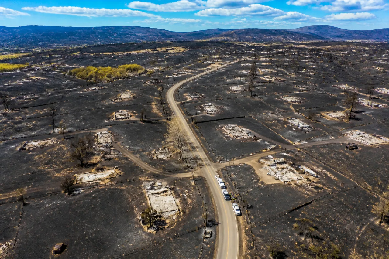
The Aspen Acres wildfire that swept across southern Colorado this summer may have destroyed far more buildings than local officials have so far documented, according to a private aerial imagery company. Vexcel Data, which flies post-disaster surveys, identified 780 unique structures lost inside the fire perimeter in Pueblo and Custer counties. That total includes not only houses and commercial buildings but also garages, barns, sheds and other outbuildings.
How the new count differs from county tallies
Pueblo County officials have confirmed the loss of 192 homes and four commercial buildings, figures that reflect damage assessments teams are still compiling after the blaze, which ignited June 29. The fire has burned more than 96,000 acres, making it the seventh-largest wildfire in Colorado’s recorded history.
"Their focus right now is on homes," Gayle Perez, a Pueblo County sheriff’s office spokesperson, said when asked about how officials are structuring assessments.
County assessment methods differ from the private aerial analysis. Pueblo County has identified 661 addresses within the mapped perimeter and completed assessments on about 67% of those properties. In Custer County, assessment teams have documented 78 homes lost so far — which Sheriff Rich Smith said represents roughly 2% of the county’s residences.
Where the imagery came from and what it shows
Vexcel Data captured high-resolution photos from a fixed-wing aircraft flying about 6,000 feet above the fire, with before-and-after images dated Sept. 1, 2024 and July 5, 2026. The company routinely flies over natural disasters to analyze structural losses worldwide, Kris Wagner, Vexcel’s marketing director, told reporters.
- Private estimate: 780 unique building structures lost (homes, outbuildings, garages, sheds, barns)
- Pueblo County (official): 192 homes and 4 commercial buildings confirmed; 661 addresses identified; ~67% assessed
- Custer County (official): 78 homes reported lost; about 2% of county residences
- Fire size: >96,000 acres; ranked seventh-largest in Colorado history
| Source | Structures counted |
|---|---|
| Vexcel Data (aerial analysis) | 780 (all building types) |
| Pueblo County official assessments | 192 homes, 4 commercial buildings |
| Custer County official assessments | 78 homes |
Residents and local leaders need accurate inventories for recovery planning, insurance claims and rebuilding decisions. The private imagery offers a broader look at property-level damage because it catalogs every separate building footprint it can identify, while the counties have prioritized documenting residences and businesses in their field assessments.
For homeowners and property owners inside the fire perimeter: counties typically post guidance on how to report damage, how to reach local assessment teams and what documentation is useful for insurance purposes. Pueblo County’s sheriff’s office has been the point of contact for address identification and assessment status, and Custer County has been coordinating its own field teams.
The numbers are likely to evolve as assessment teams finish work and compare field inspections with imagery. For now, the Vexcel figures show a wider pattern of structural loss that officials and residents will have to reconcile as recovery moves forward.
Local leaders and residents I’ve spoken with in the region emphasize that reliable counts matter not just for statistics but for delivering resources, prioritizing debris removal and helping families rebuild in communities such as Beulah, Rye and other neighborhoods inside the fire perimeter.
As agencies wrap up assessments, property owners with questions about documented losses or how to report additional structures should contact their county emergency management or sheriff’s office for the latest guidance.
Ethan Maxwell, Colorado correspondent — reporting from Pueblo County.